


 |
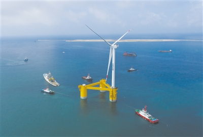
| Equipped with 6.2 megawatt typhoon-resistant wind power generating units, China's first deep-sea floating wind power equipment "Fuyao" was towed in Maoming, south China's Guangdong province on May 29. (PHOTO: XINHUA) |
It has been 20 years since China's first ocean observation satellite Haiyang (HY)-1A was launched on May 15, 2002.
In fact, the research of ocean satellites in China can be traced back to 1986, said Lin Mingsen, director of National Satellite Ocean Application Service (NSOAS), who was among the first scientists to engage in the research work and tackle the conundrum of microwave scatterometer sea surface winds remote sensing in 1995.
It was not until 1997 that the HY-1 series satellite project was approved. As the deputy chief designer of HY-1 series ground application system, Lin continued his research work with perseverance. Thanks to Lin and his team's hard work, China finally had its own ocean satellite.
Trail blazing marine monitoring
Since then the country has fast tracked ocean satellite development. HY-2A, China's first marine dynamic environment satellite was sent into space in 2011. Ten years later, HY -2D was launched successfully. Together with HY-2B and HY-2C, China established its first marine dynamic environment network, which requires only six hours to monitor 80 percent of the global ocean, the world class level.
The HY-2 series satellites also work in tandem with in orbit HY-1 series satellites, to combine marine dynamic environment monitoring with marine resource exploration.
In April this year, the Gaofen-3 03 satellite successfully networked with the orbiting Gaofen-3 01 and Gaofen-3 02 satellites, marking the formation of China's first land-sea radar satellite constellation.
The networked HY-1 series, HY-2 series, and Gaofen-3 series satellites further improved the country's multi -dimensional marine monitoring system.
Practical application
"The ocean satellites of our country have evolved from a single model to multiple ones, and from being used for test application to operation service," said Lin.
In fact, ocean satellites data has been adopted in a broader and deeper sense, such as China's polar scientific expeditions, where it plays an important role. During the country's 11th scientific expedition to the Arctic in 2020, a customized satellite observation plan was made for the research icebreaker Xuelong 2. The accurate and timely data from the ocean satellites provided information guarantees for submerged buoy retrieval and safe operation on ice stations.
The ocean satellite data was also used for disaster prevention and control. In September 2018, the super destructive Typhoon Mangkhut hit the southern part of China. HY-2A provided the latest data regarding the wind field, playing a key role in predicting the route of the typhoon.
In the summer of 2020, the Poyang Lake area in east China's Jiangxi province suffered from floods. HY-1C, HY-1D and Gaofen-3 satellites sent back high-quality images and data, helping the decision making for post-flood reconstruction.
Ecosystem protection also benefits from ocean satellites. Spatial distribution maps of mangrove forests in Shankuo county, south China's Guangxi Zhuang Autonomous Region were made based on remote sensing data acquired by HY-1C, offering basic data for the monitoring of large-scale spatial distribution of mangrove forests in Guangxi and evaluation of their growth situation on a macroscopic scale.
International cooperation
Apart from strengthening its own capabilities in ocean satellites, China continues to cooperate with other countries and international organizations.
China-France Oceanography SATellite (CFOSAT) was the first satellite jointly developed by China and France. Launched on October 29, 2018, CFOSAT was mainly used for marine dynamic environment monitoring, realizing the large-area and high-precision observation of wind and waves on the sea surface.
In February 2020, both countries agreed to share the observation data from CFOSAT with scientists across the world. Many researchers have adopted this data to optimize weather forecast systems and research global ocean disaster prevention and control.
European Organization for the Exploitation of Meteorological Satellites (EUMETSAT), the European operational satellite agency for monitoring weather, climate and the environment from space, has signed several agreements with NSOAS, China Meteorological Administration and China National Space Administration on monitoring the atmosphere, oceans and climate from space.
China also actively participated in the meetings of the Coordination Group for Meteorological Satellites (CGMS), and shared its latest research achievements in ocean remote sensing.
The networked ocean satellites of China have shown their ability to bring scientific values and practical benefits both domestically and abroad, and the country will continue to improve its capabilities in this field.